Google, working with the U.S. Geological Survey, is corralling four
decades of satellite images and using Google Earth Engine to create a
time-lapse history of the Earth’s surface.
Google, working with the U.S. Geological Survey, is corralling four
decades of satellite images and using Google Earth Engine to create a
time-lapse history of the Earth’s surface.The interactive, video-like presentation of decades of Landsat images will help scientists track changes in the Earth’s surface, fueling research in detecting deforestation, estimating biomass and mapping the world’s roadless areas, Google said in an announcement on its blog.
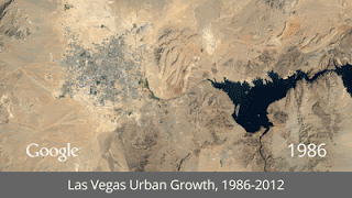
Las Vegas' urban growth, as seen through Google Earth Engine time-lapse animation.
"This news is the latest example of how the Department of the
Interior's policy of unrestricted access and free distribution of
Landsat satellite imagery to the public fosters innovation and mutual
awareness of environmental conditions around the globe," said Anne
Castle, assistant secretary of the Interior for Water and Science. "The
40-year archive of Landsat images of every spot on Earth is a treasure
trove of scientific information that can form the basis for myriad
useful applications by commercial enterprises, government scientists and
managers, the academic community, and the public at large."The Google Earth Engine data sets, which span more than 25 years, have been available to researchers for a few years now, according to GigaOm. The Earth Engine application was developed in 2010 after the company entered into a 2009 partnership with the USGS to place its archive of earth imagery online. Google collected, cataloged and stored over 900 terabytes of USGS and NASA Landsat images from as far back as the 1970s and put it in the Google cloud. Some of the images were archived on tape drives, and some existed only as negatives and prints.
The first Landsat was launched by NASA in 1972 (USGS manages the program) and has been followed by seven others; the most recent, Landsat 8, was launched in February. In the four decades since then, NASA has collected millions of images, which, though useful, could be hard to search and put into context. In 2010, in fact, NASA launched its NASA Earth Exchange (NEX), a supercomputing-powered, social networking-linked virtual lab to get a handle on all the imagery and help speed the study of Earth sciences. The agency opened NEX to outside researchers last year, and even produced some time-lapse presentations of its own.
The Google Earth Engine project is more comprehensive, however. According to Time magazine, the media partner in the Timelapse project, Google had its hands full with the data conversion. “Even getting the already digitized EROS and Landsat images from the USGS to Google took some doing, necessitating the construction of a new digital pipeline that could handle the massive stream of data.”
Google then sifted through the data to find the best images (cloud cover-free) or digitally scrubbed images for every spot on Earth and for each year since 1984. Those images were compiled into “enormous planetary images, 1.78 terapixels each, one for each year,” Google said. Google then worked with the CREATE Lab at Carnegie Mellon University to convert the yearly Earth images from a crude flip-book-like presentation into a seamless, browsable HTML5 animation that is featured on Google’s Timelapse website.
Climate researchers aren’t the only ones interested in the Google Earth Engine data. According to Time, the government of Mexico enlisted Google to help determine the damage to the country’s ground cover. Google and Landsat created a visual survey “made up of 53,000 images, representing 18 terabytes of data that required 15,000 hours of computer time to complete.” But the job was completed in one long workday, thanks to the massive Google research cloud.
Every day Google downloads terabytes of satellite images from the USGS and maintains the files on spinning disks in data centers, GigaOm reported.